Tuesday, April 30, 2013

All BWCA/Quetico Routes are Finished!

This is a big day! I finally completed all of the Quetico routes for the RouteFinder on the interactive map. It took me about one year after I had finished all of the BWCA routes. Adding the Quetico to the RouteFinder turned out to be much more complicated than the BWCA for various reasons, which is part of the reason that it took so long.

RouteFinder Coverage - All Routes Completed
In the screenshot above, the green dots represent the various points in the "network." Each green dot, portage, campsite, and entry point are interconnected by routes. You can think of the dots, portages, campsites, and entry points as intersections that are connected by roads. (For a more complete explanation about how it works, see this blog post.)

Here are some statistics about the RouteFinder:
  • There are 31,509 route points (the green dots above) in the network.
  • Out of 4,298 campsites displayed on the map, 4,144 of them are connected to the RouteFinder. The remaining ones aren't connected because they are hiking campsites, in primitive management areas, or are on a lake with no apparent access to it.
  • There are 1,041 portages that can be routed to.
  • All 95 paddling/motor entry points can be routed to or from. The remaining 15 are hiking entry points.
  • Connecting all of these points, campsites, portages, and entry points are 104,775 routes. About 30,000 of these are in the BWCA. The rest are in the Quetico.
I will be tweaking a few things in the future, but the RouteFinder is now finished and available to all. Thank you to those that have given suggestions and encouraged me in this long process.

Ranger Stations on Interactive Map

I made an addition to the interactive map - I added icons for the Quetico ranger stations. Previously, I put the Quetico entry point icons where the ranger stations were. Because of the addition of the ranger station icons, I moved the entry point icons to their respective lakes.

Thursday, April 18, 2013

BWCA Lake Contours

Awhile back I started working on adding lake contour overlays to the interactive map and the Google Earth downloads. I was using the lake map images from the Minnesota DNR Lake Finder. (Cleaning up and adding each lake is a lengthy process.) Recently I found another source of data for lake contours - the Minnesota DNR Data Deli. This service has GIS data (basically data in latitude/longitude format that can be used in mapping applications). I was able to find the lake contour data for the state of Minnesota. I downloaded the portion pertaining to the BWCA (and the surrounding area) and added it to the map.

To view the lake contours, go to the interactive map or the lake database. On the interactive map, right-click on a lake to view the options menu. If lake contours are available, you will have an option that says Show Lake Contours. Selecting this will load the data. In the lake database, a column will say if lake contours are available. The contours will load automatically when you view the individual lake page. If the lake contours are the new GIS data, the contours appear as black lines. Hovering over a line with the mouse will show you how deep it is at that spot.
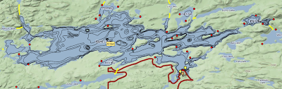
Brule Lake Contours
 I have kept all of the images that I converted for use with the map because not all lakes have the new GIS data. I will continue to work on the image overlays, but the GIS data was a huge leap forward in this effort. I was able to add 74 lakes in the time it would have taken me to add 3 or 4 images. Now 123 lakes on the map have contour data.

"What about the Quetico?" you ask. Well, not many lakes in the Quetico have been mapped. A few years ago, 16 lakes were chosen randomly by the Ontario Ministry of Natural Resources to be surveyed. It does appear to be random since the lakes chosen were not necessarily popular, well-known, or even can be accessed. I know where the data is, I just don't have access to it (yet), so I can't add it to the map. However, you can view them using Ontario's Fish ON-Line map. Here is how you can use it:
  1. Go to Ontario Fish ON-Line
  2. Click on the "I agree" to get to the map
  3. Click on the search by water body name button on the left
  4. Type in Dahlin and press enter
  5. Click on the red A marker that shows up in the middle of the screen
  6. Mark the Lake Depth Contours box
  7. This should show the contours for all of the lakes that have them, not just Dahlin.
Here is the list of Quetico lakes that I know have lake contour data:
  • Badwater
  • Ballard
  • Bentpine
  • Brewer
  • Conk
  • Dahlin
  • Darkwater
  • French
  • Gratton
  • Jack
  • Little Roland
  • Lynx
  • Middle Roland
  • No Man
  • Pond
  • Pulling 
Why did it take me so long to be able to find all of this data? Well, I didn't know the technical term for lake contour data. It's bathymetry. Once I started using the right search terms, I was able to find it pretty easily.

Monday, April 15, 2013

Faster Calculation in RouteFinder

Yesterday I made a change to how the RouteFinder works. Previously, every time a route was calculated, it was calculated from scratch. If it took 90 seconds to complete, it would take that long every time it was calculated. Now, the first time it is calculated, the results are saved. Every time after that, the results from the previous calculation are used. It just takes a second to access the results and send them back to your browser.

The advantages to this method is that it becomes much easier to share a route with others. While it may take a bit longer (not much, but a bit) to calculate the first time, it should be much faster every time after that. Everyone accessing the route will not have to wait for the website to calculate it.

This update also somewhat changes the strategy in calculating long routes. I usually suggested adding destinations along long routes, at least at every spot where the route changed direction. Now the decision of how many "intermediate destinations" to use becomes more of a balancing act. The more destinations that are specified, the more files that need to be accessed. The calculation will be fast, but accessing the files will take time. Long routes take a long time to calculate (with a 2 minute limit), but after it has been successfully calculated, thereafter it will be very fast.

While I believe the changes work, I will still be ironing out some wrinkles in the programming over the next few weeks, so please be patient if the RouteFinder has some errors.

Friday, April 12, 2013

Quetico RouteFinder Update

I finished the routes in the Conmee/Delahey area. Here is a map of the current Quetico RouteFinder coverage:


Getting closer to completion! I should finish the entire Quetico within the next couple of months. It has been a big project, and I find it exciting to see the "green dots" inching across the map.

Wednesday, April 3, 2013

Two Years!

Two years ago today I purchased the MNCanoeing.com domain name and started creating this website. It has been a fun journey so far. I have learned a lot, both about the BWCA/Quetico and about building websites. I have big plans for the future, so I hope that you will keep visiting and exploring.